North Carolina Floodplain Mapping Program – Preliminary Flood Data for Statesville
The preliminary flood data, including the Flood Insurance Rate Map (FIRM) and Flood Insurance Study (FIS) report, are available for review on the North Carolina Flood Risk Information System (FRIS) website at https://fris.nc.gov. Preliminary flooding information for the City of Statesville and Iredell County can be found on the FRIS website by selecting your county and viewing your community in the map viewer.
Floodplain Map:
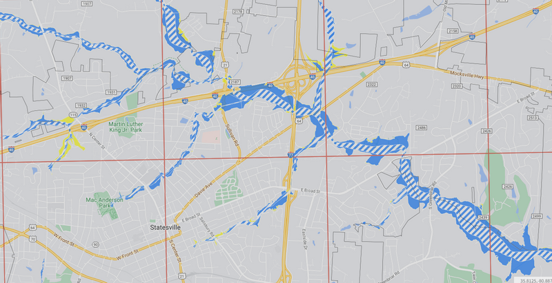
The North Carolina Floodplain Mapping Program (NCFMP), in concert with the Department of Homeland Security's Federal Emergency Management Agency (FEMA), is now providing regulatory National Flood Insurance Program (NFIP) products in a digital format accessible via a website interface on the FRIS website. Preliminary Issuance products can be downloaded at https://fris.nc.gov/fris/Download.aspx?ST=NC.
The posted preliminary flood hazard data reflects restudies for portions of various flooding sources in Iredell County. This website contains all revised preliminary flood hazard and risk data for your community and provides print-on-demand capabilities for all users. The NCFMP is fully committed to ensure that the revised digital products meet current NCFMP and FEMA standards.
The community's comments on the preliminary flood hazard data and the FRIS website are an important part of the programs review process and will be carefully considered before the flood hazard data are published in final form, and ultimately applied to your local floodplain management program.
In 2000, the State of North Carolina, FEMA, and numerous other federal, state, and local agencies entered into the first Cooperating Technical State agreement, whereby the state assumed primary ownership of and responsibility for the NFIP maps for all North Carolina communities. This project included conducting flood hazard analyses and producing updated Flood FIS reports and FIRMs. Now that all 100 counties in the state have received their FIS report and FIRMs in the statewide format, the NCFMP has developed a plan and program for map maintenance that can ensure the NFIP flood map inventory adequately reflects today's flood hazards. The National Flood Insurance Reform Act of 1994 (P.L. 103325) requires FEMA to assess the need to revise and update all floodplain areas and flood hazard zones at least once every five years.
The NCFMP's vision for map maintenance is focused primarily on stream-centric revisions that will be processed as Physical Map Revisions (PMRs). By using a stream-centric approach to map maintenance, the focus shifts from large countywide map revisions that require numerous updates to smaller revisions that include only the affected stream(s). Stream-centric PMRs are scoped in a similar fashion as full countywide revisions, in that jurisdictions are contacted for their input about flood hazard mapping needs and requests. However, once the scope of work is determined for a particular stream, only the flood hazard data affected by that stream are revised. Despite the stream-centric approach, the flood hazard data for all affected counties will continue to be revised and reproduced on a countywide basis.
Public Participation Meeting
In the near future, a meeting with community officials, residents, and other interested parties to discuss the revised flood hazard information, ordinance adoption, and other frequently asked questions and concerns with be held by NCFMP. The intent of the meeting is to present the findings contained on the FRIS website, discuss the process of reviewing and adopting the flood hazard data, and to solicit public comments.
We encourage you to visit the FRIS website to review the information thoroughly before the community meeting is held. This will allow officials and citizens in the affected communities the opportunity to identify changes or corrections to non-technical information in the revised flood hazard products.
Comments may be sent to:
Kristen M. Martinenza, P.E., CFM, Chief
Risk Analysis Branch
FEMA Region IV
3005 Chamblee Tucker Road
Atlanta, Georgia 30341
770-220-3174
Steve Garrett, CFM
State NFIP Coordinator
North Carolina Emergency Management
Hazard Mitigation Program Support/
North Carolina Floodplain Mapping Program
4218 Mail Service Center
Raleigh, North Carolina 27699-4218
(919) 825-2316
[email protected]